Greetings soldiers!
First off, congratulations! You've officially reached the halfway point of the Bostock Expedition. Six months have passed since you signed your contracts, and you've (so far) survived Dinosaur Swamp. That's no small feat, considering how hostile the region is, and how so few have lived to tell about it. And don't forget that you are making history: you are part of an organized expedition that has managed to delve into ruins that have been untouched by professional salvors since the Apocalypse itself. While Deearn Neenok's ill-fated New Lazlo Expedition was the first to explore the Swamp... it seems that you all may be the first to come home alive at the end of this.
And now, onto Atlanta. These ruins mark a colossal city that was once, not only the capital of the U.S. State of Georgia, but also the very heart of the Southeast. In pre-Rifts times, Atlanta was the 39th largest city in the Old American Empire by population, and 72nd largest by area. In a country with approximately 20,000 cities by the late 21st century, those rankings are nothing to balk at. Atlanta was also an alpha class city, meaning that it exerted a significant impact on global finance, commerce, research, technology, media, arts, and entertainment. In fact, Georgia's capital represented the 17th largest economy in the world, and had the 3rd highest concentration of high revenue corporations (called "Fortune 500 companies") in the country. While most of this information is probably meaningless to you, what it indicates is that Atlanta will perhaps be the most lucrative site in the entire expedition. From what Golden Age Salvage can gather, the city's pre-Rifts wealth was enormous, and the salvage that you find (or don't find) at this location may very well make or break the expedition.
Given the enormity of the ruins, all salvage operations had to be carefully planned ahead of time in order to maximize efficiency. The recent revelation that a dragon is due to arrive in a few weeks means that every second counts. Make no mistake: without major scores in Atlanta, the expedition becomes insolvent and Golden Age Salvage likely goes bankrupt. Ingram Bostock and Lionel Hudson have sunken almost every credit they have into this venture, and Northern Gun is expecting BIG returns. Consequently, Atlanta is an important determinant in whether you get paid your due at the end of the expedition. No pressure.
The following is a brief IMCN overview of the Atlanta ruins. Let's begin...
Appearance
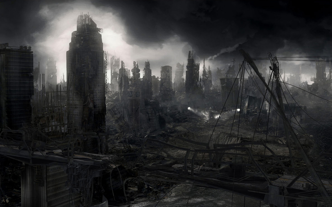
Even from a distance, the ruins of Atlanta are a sight to behold. From a dozen miles away, the first thing one sees are the skeletal tips of ancient skyscrapers peeking out above the tree line. Unlike many other ruins, Atlanta still has a number of standing edifices, thanks in part to the use of super tough Golden Age materials such as duracrete. Many of these high-rise structures have toppled over or been snapped in half; the remaining ones are nothing more than hollow towers of metal girders. Accompanying them are literal mountains of debris, created from the simultaneous collapse of hundreds of buildings during the fury of the Great Cataclysm. Some of these mounds are hundreds of feet tall, and while perhaps not as impressive as the mountainous debris piles that comprise Madhaven, they are still quite tremendous. The sheer amount of wreckage and debris that a salvage crew will need to negotiate in Atlanta is intimidating, to say the least.
The ruins of Atlanta are truly expansive. Onlookers will note that they go on for tens of miles... as far as the human eye can see. The sheer size of the ruins cannot be overstated. Seeing them from above is like looking upon a nearly endless sea of twisted steel, broken concrete, rubble mounds, and more. Including the surrounding surburbs, Atlanta has a land area of over 130 square miles. Situated at the foot of the Eastern Wall, the ruins rest at an elevation of nearly 1,200 feet above sea level. It's believed that the city's original elevation was lower, but the tectonic turmoil of the Great Cataclysm raised or shifted the city to higher ground.
What becomes clear to salvors, upon a close inspection of the ruins themselves, is the pervasive amount of fire damage that exists. Nearly every street, building, wall, and piece of rubble is marked by centuries-old burns and scorch marks. Everywhere one looks there are signs of melted metal and pockets of accumulated soot. Even digging below the surface of the rubble, one eventually hits a thick, ever-present layer of ash. This gray ash layer pervades the entirely of the ruins, indicating that most (if not all) of the city was caught in a massive conflagration at some point. Such evidence coincides with stories from the Dark Age; stories that describe Atlanta as burning day and night. It's unknown what started the fires, only that they burned for weeks - even months - making the city uninhabitable to early survivors of the Great Cataclysm.
Pre-Rifts literature indicates that Atlanta had a preponderance of trees and parks, so much so that large portions of the city were described as being secluded beneath an extensive tree canopy. The city was even known as a "tree haven" and "city of the forest." However, most of Atlanta's original green was burned away or buried by tons of ash and rubble. In fact, Atlanta produced so much ash and debris when it was destroyed that nature has been unable to adequately reclaim the ruins. Rubble is easily dozens and dozens of feet deep in much of the ruins, so trees are generally unable to grow. Only in the areas that were once pre-Rifts parks does one see the forest reassert itself. This is particularly the case in what were once the Piedmont and Bellwood Parks - the largest nature preserves of old Atlanta.
Layout
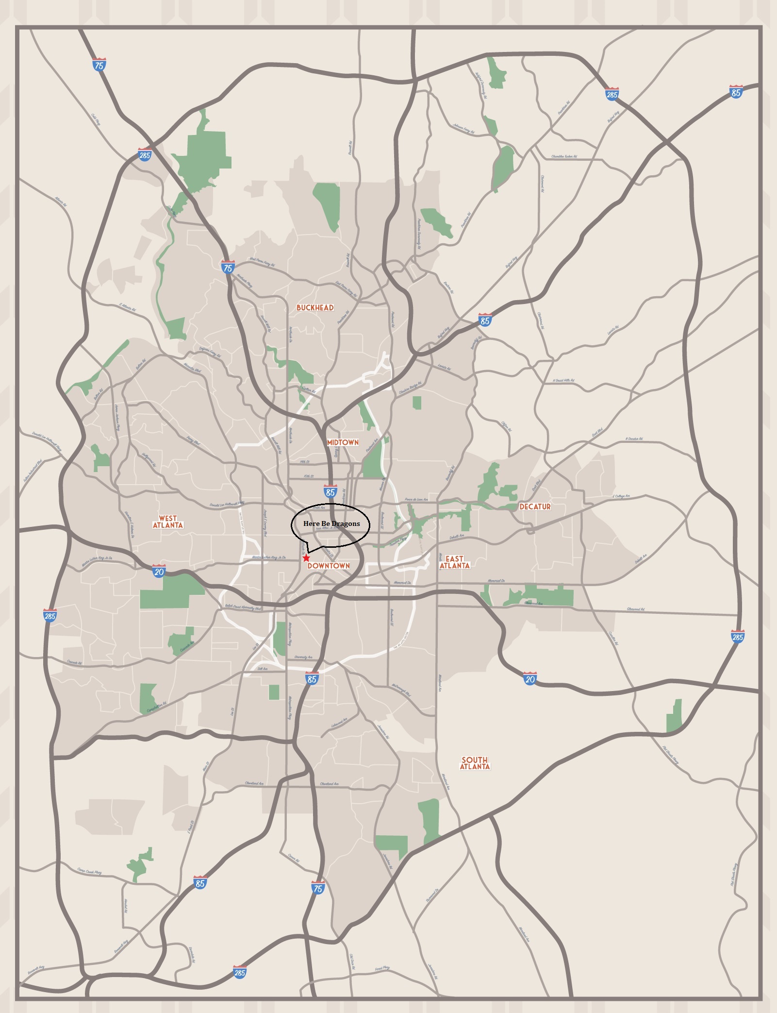
The borders of old Atlanta are demarcated by the remains of two different pre-Rifts transit infrastructures, both of which run the circumference of the city. The first is a railway corridor once known as "The Beltline." The second is an eight to twelve lane Interstate highway loop formerly known as I-285, otherwise called "The Perimeter." Though partially broken and overgrown by vegetation, large stretches of these transportation routes still exist, providing a convenient marker for travellers to identify the boundaries of Atlanta. Local barbarians recognize The Perimeter as neutral territory, and the tribes have long been using sections of I-285's elevated highway structure to meet and interact peacefully, without fear of bloodshed.
The ruins of Atlanta can be split into two major segments: the surrounding suburbs, and the City Proper. The vast tracts of suburban sprawl that once formed part of Atlanta's metropolitan area are going to be largely ignored by Golden Age Salvage. This is due to time constraints and the unlikelihood of finding worthwhile salvage in these residential zones. Consequently, our efforts will focus on the core of the city.
There are a total of five ley lines located within the ruins. They are small lines (the largest being only 32 miles long and 500 feet high), and two of them form a nexus point near the Downtown area. The lines are a double-edged sword for the local barbarians - they provide steady access to magic energy for Eco-Wizardry, but also bring monsters and ley line storms into the ruins. As such, rifts, dimensional anomalies, and alien creatures are not entirely uncommon to Atlanta.
The only waterway in Atlanta is the Chattahoochee River, which cuts through the northwestern portion of the ruins.
Click image for larger version
Salvage Itinerary
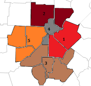
For salvage purposes, Atlanta's core has been divided into five sections (numbered 1 through 5), each roughly corresponding to a pre-Rifts district of the city. Salvage operations will begin in Section 1, and crews have exactly seven days in each section. Once the seventh day comes to a close, all operations will be relocated to the next section, regardless of the status of current operations. Excavation Section has authority to further divide each section into "neighborhoods" in order to assign sites to multiple crews. In the meantime, a survey team will scout out potential sites in the next Section, while Alpha Team commences clearing the Section of any identifiable threats (dinosaurs, spirits, etc.).
The Sections are, as follows:
Section #1 (East Atlanta & Decatur): The eastside of the ruins are thought to be the most historic part of the city, with some areas dating back to the city's founding (roughly -500 P.A./the 19th century). This was Atlanta's center of arts and entertainment, containing numerous cultural institutions, residential areas, and commercial zones.
Section #2 (Buckhead & Midtown): This section represents the affluent or "uptown" portions of Atlanta, where one finds many demolished high-rises, office buildings, commercial and financial districts, tech centers, and educational institutions. After Downtown, this Section contains what were Atlanta's second and third largest business areas. It appears that the largest number of surviving skyscrapers and standing pre-Rifts structures can be found in this region.
Section #3 (South Atlanta): Once the location of some of Atlanta's poorest neighborhoods, the southside apparently experienced widespread gentrification in the 2040's. It since became the location of several large corporations and institutions of higher learning.
Section #4 (Downtown Atlanta): This is the heart of the city, within which are much of Atlanta's businesses and corporations, financial institutions, governmental facilities, sporting venues, and cultural institutions. Being home to the tallest structures of old Atlanta, the ruins are "thickest" here.
Section #5 (West Atlanta): This is where much of Atlanta's manufacturing zones were located. Along with vast residential and business areas, Atlanta's westside contained factories, warehouses, tech centers, and military bases.
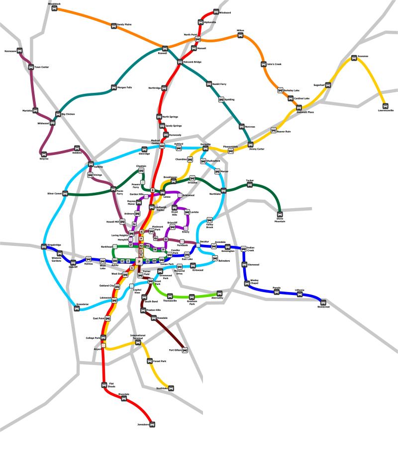
Click image for larger version
The Underground
Cut from the bedrock beneath the city, the Metropolitan Atlanta Rapid Transit Authority (MARTA) tunnels are a vast network of interconnecting subway tunnels that span the entire circumference of the city. They are still known thanks to the many signs and markings left throughout the city ruins. The tunnel system is comprised of 48 total miles of tunnels reaching a depth of 120 feet below ground, connected to 38 rail stations on four service lines.
The tunnel walls are made of rough-hewn granite, never polished or covered over by the original engineers. The floor is a mosaic of slate and granite tiles that have withstood the centuries with resilient beauty. Despite the ravages of earthquakes, flooding, and wildlife, there are still large portions of the tunnels that are habitable, though what level of habitability depends on one's standards. Fifty years before the Great Cataclysm, most of the original track and wheel trains were replaced with bullet-fast hover trains, the husks of which still clog many tunnels. The train cars are said to have been used as homes by barbarians for centuries, the original insides gutted and rebuilt by generations of squatters. Train cars and debris are also used as boundary markers and blockades to deter trespassers and keep out predators. Because many of the trains servicing the MARTA system were hover vehicles, the tunnels themselves were reconstructed as to have smooth, curved floors made of concrete rather than the gravel beds used for the rail and tie system that predated it. These smooth, curved walls and floor enhanced the speed and cushion effect of the trains going by.
The MARTA tunnels are important for a number of reasons. Aside from the possibility of containing hover-locomotive and mass transit tech from the Golden Age, the subway system may also provide shortcuts to salvage sites that are inaccessible (or difficult to access) from the surface. Certain locations that were buried under hundreds of tons of debris might be easily approached and entered from below ground. The tunnels were constructed to connect to important destinations around Atlanta, and this includes tech centers, businesses, and government facilities. As such, they will likely lead directly to valuable salvage sites. Alpha Team will be assigned to survey portions of the MARTA tunnel system and clear them of any potential threats or blockages/obstacles. Members of Excavation Section will accompany Alpha Team in order to evaluate the structural integrity of the tunnels, and to determine problem areas. Use of explosives or heavy weapons is prohibited, for obvious reasons.
Along with the danger of cave-ins, it is safe to assume that local wildlife have taken to living in the tunnels, as have barbarians and other lifeforms. Also keep in mind that the smooth design of the tunnels makes them particularly effective as channels for running water. Consequently, no one is permitted into the MARTA tunnels during even light rain storms, as the risk of flash flooding inside the tunnels is too high.
The darkness and confusing layout of the MARTA system makes getting lost a distinct possibility. Members of Alpha Team should employ a magical or technological means with which to mark their route through the tunnels. Radio contact should be made at fifteen minute intervals, though communication with home base may become impossible in the deeper portions of the MARTA system.
Sites of Note
Georgia State Capitol: This is the main office for the government of what was once the State of Georgia. The building itself is said to be architecturally impressive, and houses a number of books, records, and cultural artifacts that could be of value, as well as information about the rest of the ruins.
Georgia Institute of Technology: More commonly known before the Rifts as "Georgia Tech," this was once a well-known pre-Rifts university whose curriculum emphasized science and technology. The main campus, located in the Midtown part of Atlanta, housed libraries, workshops, technology-equipped classrooms, and research buildings. There is likely to be a trem-endous amount of salvageable technology, technical manuals, digitally stored information, and more.
Five Points: This name refers to the convergence of five streets in Downtown Atlanta, and residents long regarded the intersection as the center of the city. This spot represents a concentration of government buildings, businesses, and cultural institutions that may prove valuable. Locating the Five Points can also help serve to geographically orient the expedition, providing a frame of reference for finding other sites in the city.
High Museum of Art: Research indicates that this cultural institution was the largest museum of its kind in the Southeast. It supposedly ranked in the top 100 museums in the world, which indicates that it probably has an impressive collection of pre-Rifts cultural artifacts. It's possible that the building, if standing, still has salvageable artwork that may be worth a few credits to the right buyers.
Federal Reserve Bank of Atlanta: The Old American Empire had a total of twelve Federal Reserve Banks; massive depositories of federal money. One of the banks was located in Atlanta. If it still exists, the bank will have large quantities of gold bullion, silver, and safety deposit boxes containing untold riches. Given that pre-Rifts Federal banks were constructed with durability and security in mind, it's very likely that the Atlanta Fed still stands.
Headquarters for the Centers for Disease Control & Prevention: Atlanta was home to the main office of an important public health institute (part of the Old American Empire's "Department of Health") located in the northeastern part of the city. The purpose of the so-called "CDC" is evident in the agency's title: to develop and apply disease control and prevention. As a premiere organization of its kind, the CDC had access to cutting edge medical technology, nano-treatments, and wonder drugs.
Corporate Headquarters (various): Atlanta served as the headquarters for many large, multinational pre-Rifts corporations. This includes an airline company, banks, an oil company, a telecommunications company, a soft drink company, and more. Some of these corporate offices may contain valuable salvage or information, and should be explored.
Fort McPherson & Dobbins Air Reserve Base: These are the two largest military facilities in Atlanta. The potential for military-grade technology and gear makes these sites top priority. Dobbins is particularly noteworthy, because research indicates that the base was also the site for a manufacturing plant run by a pre-Rifts military contractor called "Lockheed-Martin."